SonarTRX Introduction
The main focus of SonarTRX software is the generation of geo-referenced raster images from sidescan sonar recordings. SonarTRX can also be used to extract depth (echo soundings) from these recordings, for bathymetric processing with GIS or 3'rd party terrain processing utilities. SonarTRX can be part of a very affordable tool-kit for exploring & mapping the seabed from your kayak, jet ski or small boat.

SonarTRX example use:
- General shallow-water sidescan surveys
- Mapping of fishing areas
- Locating interesting scuba dive-sites
- Locating shallow-water marine debris for later cleanup
- Archaeology: Mapping of underwater archaeological sites
- Treasure hunting (ship wrecks, sunken boats,...)
- Marine habitat mapping, underwater ecology
- Search and rescue
- Costal Engineering surveys
- Pipeline and cable landing surveys
- Port and harbor security
SonarTRX supports recordings from the most affordable sidescan sonars available, including fishfinder-style products such as Humminbird sonars with Side Imaging, Lowrance StructureScan and Garmin SideVu. SonarTRX also supports generic XTF files from sidescan towfish, StarFish XTF and vendor-specific recordings from SportScan & YellowFin towfish (by Imagenex) and DeepEye 340 towfish (by DeepView.)

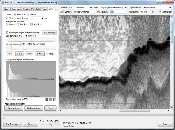
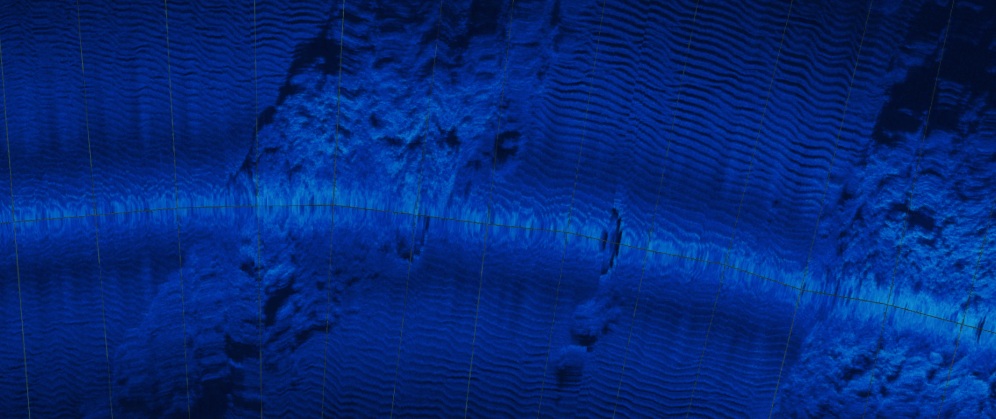
The screen-capture of the SonarTRX viewer (above) and the mosaic image below is from an area with coral reef patches and sand channels with sand waves. The above picture shows a very "noisy" environment above the reef as compared to the sand channels. It was recorded from a kayak using hardware & software costing < ~ $2,500 (U.S). (Note: Even lower cost sonars are available, making it possible to do sidescan surveys for a litte more than $1,000, including hardware & software.) The slant range corrected, geo-referenced image below is generated by SonarTRX from a recording made from a kayak, using a Humminbird 998c-SI. It shows sand channels with wave ripples between patches of coral reef:

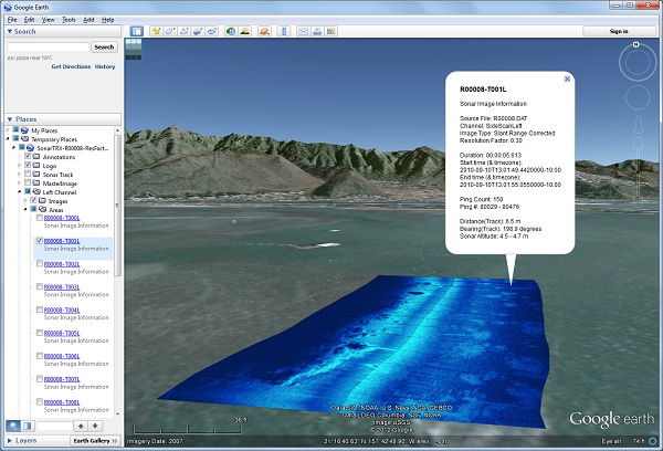
Geo-referenced images created by SonarTRX can be viewed and annotated with Google Earth Pro using KML, or they can be imported to other mapping and GIS programs for further processing. The use of KML files to reference the images, allows for low cost sharing of sidescan image-tiles by simply distributing the kml files and uploading the associated images to any web-server. SonarTRX images can be imported to ESRI products, Manifold GIS, Global Mapper, QGIS and other GIS systems.
In summary, with SonarTRX, you can:
- Import and process sidescan sonar recordings from affordable fishfinders or high-end sidescan sonars
- View data from each sonar channel, define targets, define named "clips" of data (time-interval, containing interesting data)
- Generate geo-referenced image-tiles, track lines, coverage area polygons and target placemarks
- Export sounding values (depth-along-track, as estimated by sonar, from default channel) at 1, 2, 5 or 10 seconds interval to CSV file
- Merge image-tiles into larger geo-referenced "master-images"
- Explore and annotate sonar images on a map with free tools such as Google Earth Pro, the desktop application
- Export sonar coverage areas and annotations back to the sonar via GPX files
- Produce maps by loading SonarTRX output images into ESRI, QGIS, Global Mapper, Manifold GIS or other mapping software
- Batch export Target definitions from multiple recordings, as annotated via the SonarTRX viewer's Target feature.
With the optional PlusPack features (A/B), you can:
- A: Export XYZ data (depth-along-track) from specific sonar channel to geodetic or projected coordinate systems for bathymetric processing. Export can include an XYZ point from every single sounding, or at various time-intervals. Depths (Z) can be as estimated by sonar, or as estimated by SonarTRX, via the Altitude tools in the SonarTRX viewer.
- A: Load alternate navigation data from RTK-GPS
- A: Load precise RTK-GPS elevations
- A: Load data from sidescan sonar altimeters
- B: Additional raster-image output (See PlusPack v2B information on products page.)
For a detailed list of program features, please see the Feature Matrix document (PDF)
Please see the support page for the latest release notes. There is also a short, (silent) video available from the tutorials page and example image-output on the samples page. The sample kml files can be explored with Google Earth Pro, the free desktop application.
To confirm SonarTRX's compatibility with your particular sonar recordings please contact support@sonartrx.com and include a sample recording from your sonar unit. If the sample recording is larger than 4 MB, please use a file-sharing or file-transfer service such as Dropbox, Google Drive, OneDrive, WeTransfer etc.
SonarTRX can be purchased online, via our online store, or contact sales@sonartrx.com with complete contact information, for purchase via PO/Invoice.